
Changes to LIST Web Services & LIST GeoServer
10/21/15 2:48 PM
Changes to LIST Web Services & LIST GeoServer.
As part of ongoing improvements to the overall LIST infrastructure, changes to our current web services are required.
Most notably as of December 1, 2015 the LIST GeoServer Web Service http://services.thelist.tas.gov.au/geoserver/web/ will be decommissioned. This is due to technical issues outside of our control.
To accommodate users who were accessing LIST data via the LIST GeoServer instance, our existing ArcGIS REST services have had the WMS capabilities enabled where technically possible. Go to http://services.thelist.tas.gov.au/. See example below.
 .
.
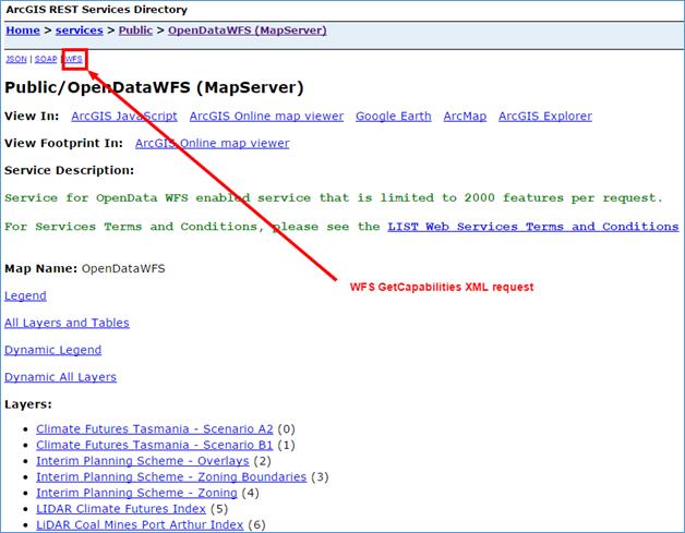
New Web Feature Server
In addition to this and as part of Land Tasmania’s Open Data initiatives, the LIST has also released a separate ArcGIS REST Service that provides users with Web Feature Services (WFS) access. This service is available at: http://services.thelist.tas.gov.au/arcgis/rest/services/Public/OpenDataWFS/MapServer
This service provides WFS access to each spatial layer that is currently available under Land Tasmania’s OpenData initiative, and has a limitation of 2,000 features per request, to manage overall LIST performance. See example below.
 .
.
For the full Services Terms and Conditions please refer to:
http://listdata.thelist.tas.gov.au/public/LISTWebServicesTermsConditions.pdf
For more information about this change of service, or the LIST in general, please contact Land Tasmania Client Services:
- Phone: 6165 4444
- Email: listhelp@dpipwe.tas.gov.au

